airport: 0030 22860 31525
portpolice: 0030 22860 22239
hospital: 0030 22860 22237
buses: 0030 22860 23812
taxi: 0030 22860 22555
museum: 0030 22860 23217
postoffice: 0030 22860 22238
Santorini is one of the few Cyclades Islands with an international airport. So that you can reach it comfortable with a direct flight from many european countries.
Of course it is possible as well to reach Santorini every day by boat from many destinations in greece.
The name Santorini was given to it by the Latin Empire in the thirteenth century, and is a reference to Saint Irene.
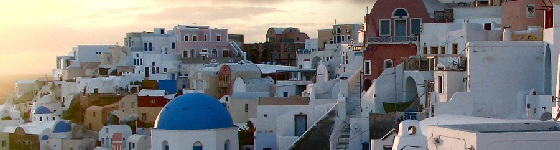
Santorini, officially Thera, are islands that are the remnants of a volcanic caldera located in the southern Aegean Sea, about 200 km (120 mi) southeast from Greece's mainland. It is the largest island of a small, circular archipelago which bears the same name. It forms the southernmost member of the Cyclades group of islands, with an area of approximately
73 km2 (28 sq mi) and a 2001 census population of 13,670. The municipality of Santorini is composed of the islands of Santorini, Therasia, and the uninhabited islands of Nea Kameni, Palaia Kameni, Aspronisi, and Christiana. The total land area is 90.623 km2 (34.990 sq mi). Santorini is part of the Santorini peripheral unit.[2]
Santorini is essentially what remains of an enormous volcanic explosion, destroying the earliest settlements on what was formerly a single island, and leading to the creation of the current geological caldera. A giant central lagoon, more or less rectangular, and measuring about 12 by 7 km (7.5 by 4.3 mi), is surrounded by 300 m (980 ft) high steep cliffs on three sides. The island slopes downward from the cliffs to the surrounding Aegean Sea. On the fourth side, the lagoon is separated from the sea by another much smaller island called Therasia; the lagoon merges with the sea in two places, in the northwest and southwest. The water in the centre of the lagoon is nearly 400 m
(1,300 ft) deep, thus making it a safe harbour for all kinds of shipping. The island's harbours all lie in the lagoon and there are no ports on the outer perimeter of the island; the capital, Fira, clings to the top of the cliff looking down on the lagoon. The volcanic rocks present from the prior eruptions feature olivine and have a notably small presence of hornblende.[3]
It is the most active volcanic centre in the South Aegean Volcanic Arc, though what remains today is chiefly a water-filled caldera. The volcanic arc is approximately 500 km (310 mi) long and 20 to 40 km (12 to 25 mi) wide. The region first became volcanically active around 3?4 million years ago though volcanism on Thera began around 2 million years ago with the extrusion of dacitic lavas from vents around the region of Akrotiri.
The island is the site of one of the largest volcanic eruptions in recorded history: the Minoan eruption (sometimes called the Thera eruption), which occurred some 3,600 years ago at the height of the Minoan civilization. The eruption left a large caldera surrounded by volcanic ash deposits hundreds of feet deep and may have led indirectly to the collapse of the Minoan civilization on the island of Crete, 110 km (68 mi) to the south, through the creation of a gigantic tsunami. This theory is not, however, supported by chronology, in that the collapse of the Minoan civilization did not occur concurrently with the date of the tsunami; that happened some 90 years later.[citation needed] Another popular theory holds that the Thera eruption is the source of the legend of Atlantis. Notes: all information is provided by Wikipedia